(1) Watershed Development Planning Using GIS and Remote Sensing
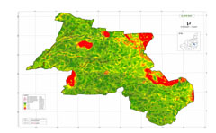
The balanced ecosystem and human system are vital indicators of a sustainable environment and better quality of human life. Towards this end, the Company has worked with Directorate of Watershed Development & Soil conservation, Rajasthan for watershed development planning using GIS and remote sensing.
The project aimed at restoring ecological balance by harnessing, conserving and developing degraded natural resources such as soil, vegetative cover and water. The expected outcomes are rainwater harvesting and recharging of groundwater, prevention of soil run-off, regeneration of natural vegetation etc.
In last 3 years the Company alongwith IL&FS Environmental Infrastructure & Services Limited (IEISL) provided consultancy services to meet the objectives of Government of Rajasthan in preparation of GIS/Remote Sensing Technology Based Thematic Layers for watershed development planning which is a necessary input for preparation of DPRs for watershed development. PDCOR covered 114 projects under IWMP 2010-11 and 2011-12 spread over more than 6 lakh hectares which has enabled the Directorate in preparation of DPRs worth Rs. 787 Crore, out of which 90% share is contributed by Govt. of India.
Considering the Company's performance in previous assignments, the Directorate further assigned preparation of GIS/Remote Sensing Technology Based Thematic Layers for watershed development planning for (i) 32 projects under IWMP 2012-13 covering 1.89 lakh hectares; (ii) Additional 12 projects of Jaipur district under IWMP 2012-13 and (iii) 53 projects under IWMP 2013-14 covering 2.83 lakh hectares. The work on all the assignments has been completed.
(2) Development of Pilot Watersheds under the Rajasthan Agriculture Competitiveness Project
Department of Agriculture, Government of Rajasthan, initiated the Rajasthan Agriculture Competitiveness Project (RACP) with financial assistance of the World Bank. The targeted beneficiaries of the project are primarily smallholder farmers with actual or potential commercial outlook in the selected agro-climatic zones, who would be supported through collective action in achieving economies of scale. The RACP includes a wide range of interventions on water conservation, agricultural productivity enhancement, livestock and agriculture value chains creation etc. which also have important environmental and social dimensions. The project is expected to be taken up in 4 to 5 regional clusters covering different agro-climatic conditions in the State and to be implemented through a menu of location approaches and interventions.
In this context the Project Management Unit (PMU) of the RACP identified a rain-fed area of about 10,000 Hectares in Dudu Panchayat Samiti of Jaipur district to develop as pilot. PDCOR was mandated to prepare Detailed Project Report (DPR) for development of the identified watershed which comprises of 24 villages spread over eight Gram Panchayats. The final report was submitted by PDCOR in May 2012.
(3) GIS based Boundary and Reference Monumentation for Forest Department
Rajasthan Forest Department is facing a number of challenges pertaining to management and monitoring of forested land involving land related conflicts. Also, the initial forest database for various forest blocks available with Rajasthan Forest Department is not adequate with respect to spatial context (GIS format). In view of these requirements, a team of PDCOR and IL&FS Environmental Infrastructure and Services Limited (IEISL) undertook preparation of “Geospatial Analysis Framework for Notified Forest Boundary Mapping & Delineation using Modern Field based Technology and Monumentation of Forest Boundary Pillars (FBP) for the Badi Line Amer No. 54 Forest Block, Division Jaipur”. The work involved high precision mapping using modern survey technology like DGPS/ETS of notified forest block and Monumentation of Forest Boundary Pillars (FBP) as part of Proof of Concept (PoC); and training and Capacity Building on DGPS Survey to Forest Officials including FBO/FSO/FRO/Sub FRO/DFO.
If you require further information on any Project(s) then please
Contact Us